

High-fidelity coastal modeling.
Deploy ruggedized oceanographic data pipelines designed for offshore wind developers and marine engineers. Translate complex ocean physics into clear, deployable commercial assets.
Precision ocean telemetry.
Bypass generic GIS software. We deliver real-time environmental compliance data and high-fidelity marine modeling directly to your enterprise APIs.
Sea-state forecasting
Sediment transport
Stress telemetry
Continuous tracking of wave height, frequency, and directional spectra to safeguard offshore wind turbines and maritime structures.
High-resolution modeling of coastal erosion, bathymetric shifts, and seafloor stability to secure critical subsea cable routes.
Real-time structural stress monitoring for offshore foundations under extreme hydrodynamic loads and heavy sea conditions.

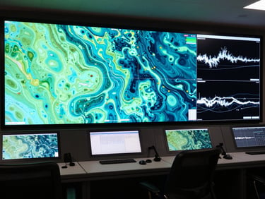
High-fidelity dashboards.
Our custom modeling interfaces aggregate multi-spectral oceanographic data into clean, actionable telemetry. No GIS overhead, just direct API streams.
Designed for environmental compliance, offshore wind site selection, and active marine resource management in challenging deep-water environments.
Deploy your data pipeline.
Get immediate access to system integration specifications and coastal impact modeling demos tailored to your offshore project.